Moments before eruption: what do Icelandic volcanoes and Czech earthquakes have in common?
15. 11. 2022
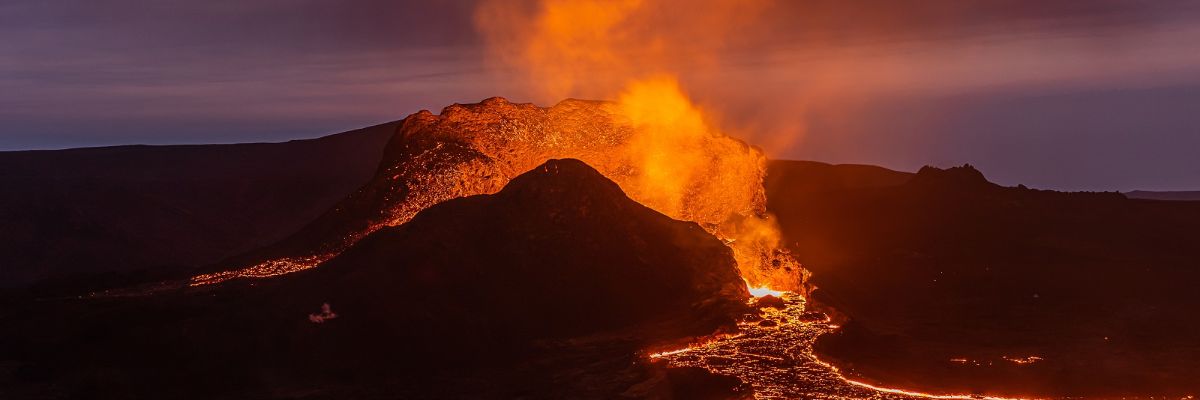
In March 2021, the Fagradalsfjall volcano erupted on the Reykjanes Peninsula in Iceland. Researchers from the Institute of Geophysics of the CAS had anticipated the event and had been monitoring the area and the increasing activity for more than a year. While the volcano was coming to life deep underground, a network of seismic stations operated by the Czech Academy of Sciences collected data directly above it, allowing Czech scientists to describe, in detail, the processes that eventually led to the eruption itself. How is this data useful in our Central European environment and why are Icelandic and Czech earthquakes so strikingly similar?
Iceland is famous for its volcanic activity and earthquakes. And yet, on the Reykjanes Peninsula, the most seismically active area in all of Iceland, we would have to wait a long time for a volcanic eruption. That’s because on average, it only occurs once every 800 to 1,000 years. Until very recently, the last time a volcano spewed hot lava here was in 1240. However, our researchers from the Institute of Geophysics of the CAS can thank their lucky stars that they did not have to wait eight centuries. On 19 March 2021, just before 7 PM, the Fagradalsfjall volcano erupted.
However, it was not an unforeseen event. Experts had been observing signs of dramatic changes under the seemingly calm surface of the volcano for a whole year. While the volcano was gradually awakening, a network of seismic stations operated by Czech geophysicists was collecting data directly above it. They were one of the first ones to know about the eruption. Because seismologists anticipated the event and had been monitoring the area for over a year, it enabled them to describe in detail the processes that eventually led to the eruption itself.
In the midst of a changing landscape
The Reykjanes Peninsula forms the south-westernmost tip of Iceland. Although it is only about 30 kilometres from the capital Reykjavik, it is a sparsely populated and desolate landscape. This is mainly due to its geodynamic activity. The peninsula is located on the Mid-Atlantic Ridge, which divides the Eurasian and North American tectonic plates. It is here that the ridge first rises above sea level. Weaker earthquakes are a commonplace occurrence, often separated by mere hours without any tremors. Volcanic activity is much rarer, but even so, blackened lava fields and the remnants of erupted rocks comprise most of the landscape.
Vegetation is sporadic here, whereas geothermal phenomena such as hot springs, geysers, and gas seepage are quite common. Two geothermal power stations and a nearby luxury spa utilise the energy that makes its way to the surface in the form of superheated steam. Tourists, enjoying the Icelandic mineralised water pools known as the Blue Lagoon, may not have any idea that they are in fact a by-product of one of the power stations. The Earth’s crust at Reykjanes is already hot enough at relatively shallow depths to make the use of geothermal energy worthwhile. In certain areas, just two kilometres below the surface, temperatures in excess of 280˚C have been recorded.
If we were to go further west – away from the tourist attractions and deeper into the volcanic landscape – we would probably, sooner or later, stumble upon an inconspicuous engineering structure: a rod sticking out of the ground, anchored by a few metal cables. Judging by the photovoltaic panel and the small wind turbine at the top, we probably wouldn’t be able to tell what it was for – perhaps because we would only be guessing its purpose by looking at just a small part of the whole. In fact, the most important component is hidden belowground, in a container mounted on concrete pillars: a seismometer that continuously monitors the movements of the surrounding terrain.

One of the seismic stations of the REYKJANET network, which covers most of the earthquake-prone peninsula.
A total of fifteen similar seismic monitoring stations can be found on the Reykjanes peninsula. Together they form the local REYKJANET network, which records seismic and volcanic activity over an area of approximately sixty by twenty kilometres. The network has been in operation since 2013 and is managed by experts from the Institute of Geophysics of the CAS and researchers from the Institute of Rock Structure and Mechanics of the CAS – of course, together with the help of Icelandic colleagues. It is the only seismic network operated abroad by the Czech Academy of Sciences.
When the ground shakes
A similar network, called WEBNET, has been operating in the Czech Republic for over three decades. It is used to investigate so-called earthquake swarms – a series of hundreds of weak tremors lasting several weeks that are a typical occurrence in western Bohemia. The swarms occur repeatedly in this landscape every few years, and so the network has a track record of successful measurements. All 25 stations, which cover most of the swarm occurrences between the Czech towns of Cheb, Aš, and Sokolov, are now functioning under optimal conditions: they are located away from sources of disturbance, away from human activity, and years of experience have been reflected in the accuracy of the calibrations. “This renders our data from western Bohemia particularly valuable to the global seismological community,” Jana Doubravová adds. The know-how the experts gained from the Czech environment were thus used in the construction of the network in Iceland.
What is an earthquake swarm?
An earthquake swarm is a sequence of seismic events that occur in rapid succession and whose foci are clustered close together. They occur mainly in volcanically active or geothermal areas. On the European continent, seismologists have detected them in Iceland, Greece, and Italy, but also in western Bohemia (Czech Republic). It is typical for swarms that the differences in the magnitude of individual tremors are significantly smaller than in typical tectonic earthquakes. This is because during the course of the swarms, the accumulated strain energy is released gradually on the tectonic faults, resulting in tens or even thousands of weak earthquakes. Stronger earthquake swarms are often accompanied by characteristic rumbling sounds, and the strongest tremors can cause minor damage to buildings. Five such stronger swarms have occurred in western Bohemia in the past 22 years. During the most recent one, in 2018, residents of northern Prague and the city of Liberec could feel some of the tremors.
Why are scientists from the landlocked Czech Republic interested in remote Iceland anyway? It’s because the earthquakes on the Reykjanes Peninsula behave in strikingly similar ways to the ones they’ve been tracking here for decades. The tremors in the Czech Republic are earthquake swarms and occur in clusters that last for days, weeks, sometimes even months. However, the two locations could not be more different. Iceland lies on a site of constant tectonic movements, whereas the Bohemian Massif is stable and geologically compact. Measurements of seismic activity in Iceland could thus help explain why earthquake swarms also occur in the Czech Republic.
In its early days, however, the network in Iceland was not up to par with its Czech counterpart. The lack of instruments meant researchers had to use three different types of seismometers to set up the network, and it was laborious having to piece together the overall data. Moreover, the stations were not connected to the internet, forcing researchers to have to return to them every few months to collect the data. In 2019, the Czech Academy of Sciences provided funds to upgrade the Icelandic network. “The new instruments were tailormade for us,” Josef Horálek recalls. “It really was sheer luck, because nine months later, this extremely strong seismic activity began, which, after another year, resulted in the volcanic eruption.” Some of the older equipment would have been unsuitable for this type of signal, as it was too sensitive, and it would not have been possible to analyse as much from the acquired data.
The relative calm before the storm
Unusually strong seismic activity in early 2020 turned the Reykjanes Peninsula into a sensation. Experts from all over Europe flocked to Iceland, many equipped with their own instruments. Researchers from the University of Cambridge also started taking measurements, but their seismometers were too sensitive, and much of the data they collected could not be used.
The position of Czech researchers was quite unique. From the very beginning, they had a working and well-equipped network at their disposal that encircled the volcano from all directions. The Icelandic Meteorological Office itself, which is responsible for monitoring seismicity in Iceland, operates only five stations on the peninsula, and these are positioned in its most remote corners. They are part of the seismic warning system. The Czech network is therefore denser and its measurements more accurate, even though its primary purpose is not to measure volcanic activity. However, the increasing tremors of the 2020 seismic activity took the form of earthquake swarms, which the Czech network was adapted to measure.

The red pin indicates the focus of volcanic activity. The yellow labels indicate the seismic network stations in the vicinity.
The hypocentres of the earthquakes migrated across the peninsula, making it clear that their source was the movement of magma at depths of several kilometres below the surface. The volcano was taking its time, and seismic activity increased only slowly. Yet in a single year, the seismic network recorded more than 30,000 earthquakes, the strongest one occurring in February 2021. It was even felt in the capital, Reykjavik, fortunately without causing any serious damage. However, in certain places on the peninsula, the ground surface rose or fell by 12 centimetres. On 19 March 2021, five kilometres from the highest point, an eruption occurred.
Those who wait
Because of the COVID-19 pandemic raging at the time and strict quarantine measures, it was very difficult for experts to reach the territory of the island. It wasn’t until six months later in September that researchers were able to visit the site of the erupting volcano. But even then, the volcano was still showing considerable activity at regular intervals, and while some days there were no visible eruptions, on several other days, it spewed lava incessantly. The Czech geophysicists even had to ask their Icelandic colleagues to relocate one of the stations, as the flowing lava threatened to engulf it.
However, once the plane with the Czech team on board finally landed in Iceland, the volcano calmed down completely. All that remained at the site of the eruption was a black and grey undulating landscape with furrows through which, not long ago, streams of hot lava had flowed, completely altering the landscape. The debris that had accumulated in the deep valleys had solidified but was still warm.

The lava moved more slowly and at first flowed from only a few spots, which is why the Czech researchers were able to take pictures of the lava field at such close range.
Researchers monitored the volcano and its surroundings for the next few days, but the only seismic activity recorded were tremors caused by the footsteps of colleagues who had taken it upon themselves to repair one of the stations. None of the measurements indicated that the volcano was still active. The disappointed members of the expedition were about to leave for the Czech Republic when they received a message in the middle of the night from their Icelandic colleagues: the volcano was awakening.
It was still dark when the researchers set off. Soon, they were treated to a unique sight: gushing streams and rivers of flowing lava illuminating the surrounding night. Even they were surprised by how thin and wild the lava was as it moved, even though on the surface it solidified quickly. The next day, in thick fog, they returned to the volcano. “The unique thing about the whole situation was that the outpouring of the lava was gradual. Although it flowed quickly and the gushing geysers reached a height of hundreds of metres, no poisonous gases were released into the air,” Jana Doubravová recalls, adding that such peaceful eruptions are rare. Nevertheless, the police soon closed the area off for safety reasons. In addition to the original crater, lava was beginning to ooze from approximately ten fissures at the foot of the hill.
Below the surface
On 18 September 2021, the flow of lava stopped for good. Measurements from the REYKJANET seismic network were then used by Czech researchers and foreign colleagues to produce a series of studies describing the mechanics and processes that preceded the eruption. The study by the research team from Iceland, Germany, Italy, China, and the Czech Republic, was published in the prestigious journal Nature Geoscience, focused on explaining the uplift and subsidence of the Earth’s surface in the wider area surrounding the volcano.
A massive reservoir of magma is thought to lie around 15 to 20 kilometres below the volcano. Over a period of hundreds of years, carbon dioxide was being released from this reservoir and seeped upwards through cracks in the permeable rock, closer to the surface. About four kilometres underground, it hit a deposit of geothermal water, in which it dissolved. The resulting build-up of pressure then raised the surface of the ground in places that are often actually several kilometres away from the eruption site. As the pressure decreased, the ground surface also dropped, this process repeating several times.

Josef Horálek and Jana Doubravová form the heart of the team that is researching earthquake swarms in the Czech Republic and Iceland.
The fundamental similarity between Icelandic earthquake swarms and those in western Bohemia lies in this mechanism. Like the wasteland of the Reykjanes Peninsula, the landscape of the western tip of the Czech Republic is a product of past volcanic activity. Carbon dioxide plays an important role here as well. At depths of around 7–10 kilometres, CO2 mixes with superheated mineralised water at temperatures of up to 300˚C. Pressure then pushes the mixture from the depths of the Earth through a system of fissures to the surface. It travels mainly along tectonic faults, reducing their strength. This gradually releases the tectonic stresses built up on the faults and creates earthquake swarms.
Back to steam
Earthquake swarms in the Czech Republic, whatever minor damage they cause, have two positive aspects. Firstly, they release the accumulating energy gradually via a series of weak tremors and thus have less negative impact on the lives of the inhabitants in the area. Secondly, they highlight the fact that we too have geothermal resources. In fact, the cooperation between the Institute of Geophysics of the CAS and Icelandic researchers is based on a project of the Technology Agency of the Czech Republic called Natural Seismicity as a Tool for Searching for Geothermal Energy Sources, which is funded by the European Economic Aid. Iceland is already using electricity from turbines powered by steam from the bowels of the Earth, but these resources are located too deep in western Bohemia to be considered worthwhile. However, the data from the Icelandic eruption and the models based on it bring us imaginatively closer to these resources. For now, they are valuable primarily to the scientific community. “This is the first time we have such measurements at our disposal. They are unique not only in the Czech Republic, but at least on a European scale,” Josef Horálek says.
In the future, thanks to earthquake swarms, various opportunities may bubble up to the surface – just like the subsequent seismic activity on the Reykjanes Peninsula, heralding that the Fagradalsfjall volcano may indeed be coming back to life.
________________________________________
The text is taken from the Czech-language A / Věda a výzkum magazine, published by the Czech Academy of Sciences. The issue (in Czech) can be read below:

________________________________________
Ing. Jana Doubravová, Ph.D.
She has been working in the Seismic Department of the Institute of Geophysics of the CAS since 2010. She is an expert in the processing of measured data and detection of seismic phenomena using automatic algorithms. She also deals with localising earthquake swarm foci. She is involved in the maintenance and evaluation of results from WEBNET and REYKJANET. She is a populariser of her field of research in the press and other media and manages the seismic exposition in the Geophysical Museum in Skalná.
Ing. Josef Horálek, CSc.
He leads a team investigating earthquake swarms and local seismicity. He established a research program for seismicity monitoring using WEBNET in the regions of Cheb and Kraslice and REYKJANET in Iceland. His research includes advanced data processing and evaluation methods, source and trigger mechanisms of earthquake swarms, and microearthquake activity. Since 1972, he has worked at the Institute of Geophysics of the CAS. He has authored or co-authored more than fifty scientific publications, mostly on earthquake swarms.
Prepared by: Jan Hanáček, Division of External Relations, CAO of the CAS
Translated by: Tereza Novická, Division of External Relations, CAO of the CAS
Photo: Shutterstock; Institute of Geophysics of the CAS; Jana Plavec, Division of External Relations, CAO of the CAS
 The text and photos are released for use under the Creative Commons license.
Read also
- Czech Academy of Sciences Evaluation – Beyond Metrics, Accent on Peer Review
- Ordovician Fauna Beneath Prague – New Arthropod Found During Metro Line Dig
- Wildfires on the Rise in Europe and Set to Double by 2100. What Can We Do?
- The CAS Photogenic Science Contest Invites Entries
- The CAS Launches New Research Programs as Part of Its Strategy AV21
- Academy Assembly – Thirteen Priorities to Boost Basic and Applied Research
- We Must Prioritize Science, Czech President Petr Pavel Says on His Academy Visit
- Radomír Pánek Visits CAS Institutes, Aiming to Strengthen the Academy’s Unity
- Small but Mighty – The Enceladus Moon Is Flexing with Saturn’s Magnetic Field
- Light vs. Antibiotics – Can We Get Harmful Substances Out of Our Water?
The Czech Academy of Sciences (the CAS)
The mission of the CAS
The primary mission of the CAS is to conduct research in a broad spectrum of natural, technical and social sciences as well as humanities. This research aims to advance progress of scientific knowledge at the international level, considering, however, the specific needs of the Czech society and the national culture.
President of the CAS
Prof. Radomír Pánek started his first term of office in March 2025. He is a prominent Czech scientist specializing in plasma physics and nuclear fusion.